2022 GCGCD Carrizo Water Rights Allocation
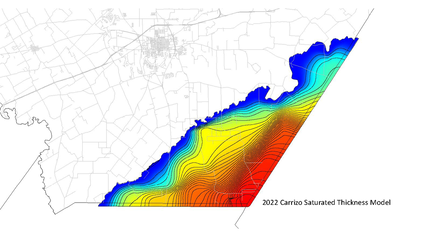
NEW Saturated Sand Thickness Model
release date June 1, 2022
Understanding aquifer thickness is crucial for groundwater resource management and equitable water rights allocation.
The Guadalupe County Groundwater Conservation District uses a saturated sand thickness model to allocate water rights for property over the Carrizo aquifer.
Click on the buttons below to locate the 2024 Carrizo Water Rights - expressed in acre feet per year
using the Annual Production Cap of 16,000 Acre-feet/Year for your parcel by last name or property ID
*Any errors to name or parcel ID must be directed to the Guadalupe County Appraisal District 830-303-3313
Home - Guadalupe Appraisal District (guadalupead.org)
GCGCD RESOLUTION 04132023
using the Annual Production Cap of 16,000 Acre-feet/Year for your parcel by last name or property ID
*Any errors to name or parcel ID must be directed to the Guadalupe County Appraisal District 830-303-3313
Home - Guadalupe Appraisal District (guadalupead.org)
GCGCD RESOLUTION 04132023
Wilcox Aquifer water rights are allocated at up to 1/2 (one-half) an acre foot per surface acre.
To learn more about GCGCD water rights and spacing - read our Rules.
To learn more about GCGCD water rights and spacing - read our Rules.